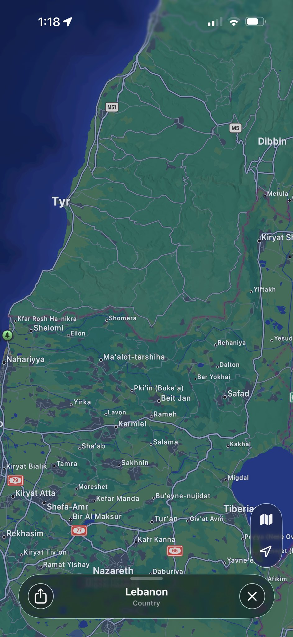
ALL of Lebanon, not just the south. check along any border where there are small towns on each side, and the Lebanon side does not have any label names while the other side does.
I'd like to see a picture from like a year ago.
Did they actively remove them, or is this just another case of Apple Maps being shit in countries Apple doesn't care about?
Apple supports Trump and Netanyahu. I don't support Apple and own none of their products and never will.
The Apple closed environment is the authoritarian version of software. It's a monopoly.
That is not a thing, and even if it were, they're towns. They don't move on their own. The IDF could pick up a paper map published 20 or more years ago with the same information.
This is what happens when a company receives enough requests internally or from customers or other organizations or governments to take a geopolitical stance. It happened with the "Gulf of America", it happens when companies list Hong Kong without the suffix "(PRC)", and it's happening here. It also happens when companies use flags to describe languages or show country borders.
10 Comments
culprit@lemmy.ml · 31 pts · 149d
ALL of Lebanon, not just the south. check along any border where there are small towns on each side, and the Lebanon side does not have any label names while the other side does.
mech@feddit.org · 24 pts · 148d
I'd like to see a picture from like a year ago.
Did they actively remove them, or is this just another case of Apple Maps being shit in countries Apple doesn't care about?
stumu415@lemmy.zip · 15 pts · 148d
Apple supports Trump and Netanyahu. I don't support Apple and own none of their products and never will. The Apple closed environment is the authoritarian version of software. It's a monopoly.
kingofras@lemmy.world · 5 pts · 148d
Did a check on Google Maps too. They certainly have also removed some data, but not on the same ctrl-alt-del level as Apple.
Be warned though. I did one random scroll through Southern Lebanon and it’s revolting. And these satellite images are outdated by months.
https://maps.app.goo.gl/XNmUdaBuUVUA6qau7
twinnie@feddit.uk · 1 pts · 149d
They could’ve done it as a legal thing to make sure the IDF wasn’t using it to target centres of population.
modestmeme@lemmy.world · 31 pts · 148d
Just a hunch: IDF has their own maps of the area that are highly accurate.
kbobabob@lemmy.dbzer0.com · 8 pts · 148d
Nah, it's Apple maps all the way. Trust me bro.
Carmakazi@piefed.social · 1 pts · 148d
You'd be surprised how often soldiers on both sides of the Ukraine war were using civilian navigation and comms early on.
fiat_lux@lemmy.world · 22 pts · 148d
That is not a thing, and even if it were, they're towns. They don't move on their own. The IDF could pick up a paper map published 20 or more years ago with the same information.
This is what happens when a company receives enough requests internally or from customers or other organizations or governments to take a geopolitical stance. It happened with the "Gulf of America", it happens when companies list Hong Kong without the suffix "(PRC)", and it's happening here. It also happens when companies use flags to describe languages or show country borders.
socsa@piefed.social · -2 pts · 148d
Bruh