At some point that was probably above ground. The reason many cities have these section not aligned is because they were aligned to the train tracks, not to a compass.
Sim City 4 is the best version of the Sim City games, and is 75% off on GOG right now, $5 / £4.
Cities Skylines 1 is the best modern city builder, 3D and a lot of fun plus well designed. But only really worth it when it's on sale; lots of DLC and overpriced as a package when not on sale. Avoid Cities Skylines 2 - it's just not fun and hasn't been fixed - maybe they will one day fix but I doubt it 2.5 years in..
The original developer has literally been pulled off of Cities Skylines 2. Maybe the little developer that Paradox put on it to crank out DLCs will do a good job and fix it, but I doubt it.
And don't forget the Network Addon Mod for Sim City 4. Improves traffic simulation and adds a whole bunch of new sorts of transportation stuff. It's really the expansion pack Sim City 4 never had.
IMO the painful thing about it is that it was clearly just too ambitious of a simulation and they made it unmanageable, so then they backpedaled and made it too easy by having a lot of the systems automatically balance themselves (electricity from neighboring cities, for instance)
Yeah, Cities Skylines had traffic that was reactive to design. I've played some CS2, and while some things are improved (like lane connection), it feels like the traffic is just simulated sprites based on a traffic congestion variable for the area or something. Upgrading roads sometimes helps, but providing better routes doesn't always help like you would expect. It feels very disconnected and rewards linear progression rather than skillful or smart gameplay. I still play CS1 and I check in on CS2 once or twice a year to see if it still sucks. I did enjoy the bike patch to some degree, but the gameplay in general just seems artificial and lame. CS1 may be old with mediocre graphics, but it's still a 9/10 game in my opinion and you can buy in cheap nowadays to get caught up on DLCs and such. I have nearly everything except the radio packs. The menus are inconsistent and the way they organize things doesn't always make intuitive sense. I think they would be better off recreating CS1 on a more modern engine than trying to reinvent a masterpiece. For me CS2 was the biggest disappointment of the gaming decade. With that said, lots of games sucked on release. Fallout 76 grew into it's shoes, Stalker 2 was panned at release and is now much more highly regarded. I hope CS2 finds its way back into sync with the community, but I'll be enjoying CS1 and other games until that happens. Thankfully MS hasn't completely destroyed Minecraft. I practice city design on a much smaller scale on there (more "place making", less traffic management, more roleplay, less mechanics).
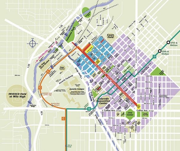
At least with places like Denver and other western cities it's pretty straightforward how it happened - everything built along the river. Access to the river was key.
Being a boom/bust city means that a much later boom they adjusted.
Then even older cities (think Boston) grew before any opportunity at planning could happen.
Denver was two cities - Auraria (correction from Aurora thanks to @negativenull) and Denver. One was built to align with the river, the other with compass points and then they grew big enough to smush into each other and neither was willing to concede to the other.
Also Denver’s namesake, a Kansas politician, never even visited. It was a failed attempt to lure him here.
I can't see the pic in your comment, but I am gonna guess Broadway and Lincoln between 19th and 20th?
Interestingly enough, Denver has 3 main grids:
The range and township grid as the typical NS/EW grid, the Araria grid by DU which is largely built over, and the downtown grid, the last two of which are aligned to Cherry Creek and the Platte River, though I'm not certain which one to which waterway. If it wasn't for one-ways, that area would be screwed up beyond belief. As it stands, it just looks a little odd and everyone needs to try to pick their lanes in advance. :D
In my experience, many cities old enough in the US. Almost every biggish city where I live has the center of town laying differently than the newer, surrounding areas. There was a time when they oriented things different than how they plan it out now so now the older downtown areas look cock-eyed on a map/satellite image.
Grids were more efficient for pedestrians and unmotorized transport, but the caveat is that motorized transport, especially on large grids, will often be driving faster than is desired among the pedestrian traffic.
Which is why the ethos has changed off of grids to the windy, curvy roads that naturally encourage slower speeds...no straightaways to really build up speeds like you can with a grid.
Most town centers, which have likely existed before the car did in large numbers, are still laid out in a grid...but youll notice as you get farther out, when the neighborhoods started getting built in the post wwii era and the rise of the burbs, are not generally grids.
This is an easier way to eyeball how old a particular neighborhood is...with some caveats and exceptions of course.
A grid is still most efficient, but were trading efficiency for safety which is reasonable....weren't too many idiots doing 60mph on 35mph city streets like we have today.
May I introduce you to Magnasanti: No road grid. A map of mostly skyscrapers, libraries, and subway stations. https://youtu.be/NTJQTc-TqpU
“Sims don't need to travel long distances, because their workplace is just within walking distance. In fact they do not even need to leave their own block. Wherever they go it's like going to the same place.”
Reverse image search has mixed results... A few say Florida, but the top one says Wyoming. I'd guess the one that says Jacksonville, Florida is most likely.
I was thinking maybe an old Spanish Land Grant or something maybe. But, that doesn't seem to be the case. That block is orientated north, while the surrounding blocks are oriented parallel with the coast, just east (right) of the crop. So then, I thought that maybe it was one weird plat of lot and the city grew around it. Nope. The thing is, you can look up all the plats (thanks to Florida's sunshine laws) back to the original bureau of land management surveys (thanks to the BLM & labins.org).There aren't even that many. This neighborhood has been like this from it's beginning as far as I can tell. Around 1911 the whole town, then called Pablo Beach, was platted. And right there in the middle is this weird block, seemingly by design and without explanation. It was replatted in 1922, keeping the twisted block intact. It's been residential neighborhood and largely unchanged since then (at least as far as the parcels and streets are concerned).
Two lawyers got in a pissing contest on developing the land they owned.
My great-grandfather apparently had a story about it. It involved lots of booze, a prostitute, and a horse. Then again most of his stories had the same theme so the truthfulness of the story is up for debate.
Missoula is a bit odd on a few things. I attended Hellgate elementary - yes that's the name of the school.
Indianapolis built the central mile square of streets aligned with magnetic north, but then the rest of downtown aligned with true north. It’s almost aligned, which causes problems at that border.
I lived downtown for a couple of years and drove north on Illinois street to get to work. This swerve as it crossed 16th street and the corresponding confusion to drivers just about killed me a few times.
I have two options when driving to work. One is shorter and takes straight level roads through the newest part of town.
The other way is slightly longer but it's a twisty hilly road through the countryside.
I take the longer route every single day unless it is actively snowing or something. And now that hybrid WFH is a common thing, I don't often drive in the snow.
I mean, you can organise grids to be more or less stroady, and if you have too much of this going - like you have a medieval street plan - you can get the opposite thing where cars are forced through areas only suited to pedestrians, and everyone has to flatten themselves against building walls to make room.
but the point is that by not organizing it into a grid at the local level, drivers aren't going to cut through a low speed local street, keeping those streets less polluted and safer.
I mean, there's more options than just tree or grid, and if it's not strictly a tree the fastest route from A to B could be something small again. And of course trees have their own issues, like what happens if you need to get from one leaf to another that's nearby, but only "as the crow flies".
That example about having to move aside for a car going through a narrow European street is something I've actually experienced. Maybe it's just my Canadian brain but it feels unsafe.
Where I'm from cities like Boston are the norm. When I was in a grid city for the first time, I immediately got lost on the roads because everything just looks the same.
On the other hand, Americans seem to have a more intuitive sense of the cardinal directions than Europeans do from my experience. Which makes sense if you're used to roads aligned with them.
As someone who drives through Boston often: it's the worst-planned city I've ever seen. I am fairly convinced that the underground tunnel system is actually creating an eldritch sigil of chaos (a la Good Omens), and it is not uncommon to encounter a seven-way intersection, where two of those ways are train lines, but aren't marked, so at night, you can accidentally find yourself on train tracks. It's like if someone bargained with the Fey to make a city.
I am familiar with Boston, and the 2 times I have driven in nyc it was SIGNIFICANTLY easier to navigate than Boston lol. NYC was at least partially thought out, Boston is what you get when your road planner is a 3 year old toddler who threw a hand full of spaghetti on a map and said theres your streets LOL. Possibly the most annoying city I have had the misfortune of navigating lol.
Yeah, Boston is chaos and it is super easy to get lost. And you'll have two roads converging and splitting and you gotta just hope you're in the right place!
Have you considered maybe it’s easier to navigate and plan a grid pattern? I wouldn’t mind uninspired street names like 1st, 2nd, 3rd St, crossways with N, O, P, Q Ave so you at least know which direction is which. Give me that chess board layout so I don’t need to pull up a map to navigate your city please. Car C1 takes Bar G5
Japan doesn't even bother with street names, except the largest ones in big cities. If you want to find a house, they are also not necessarily numbered sequentially. Sometimes the houses in a neighborhood are numbered in the order they were built.
If you want to find a house, you go to the neighborhood map and look there. At least, that's how it used to be. Now everything is GPS. I was using GPS in a car close to 30 years ago, I wouldn't be surprised if it was the first place in the world to have consumer GPS, simply because they needed it.
Over here in 2026 we have satnav in our cars and on our bikes. We also have a system of road types that actually makes sense and that keeps traffic out of housed areas as much as possible.
You have to understand that there are places in the USA where “city planning” is completely unheard of. They seem to let landowners develop however the fuck they want. They end up with grids of identical houses with little thought of connections to services such as shopping, healthcare, recreation, etc.
Yes! I can get up so much speed on those straight roads! Blow through a few stop signs and I can easily drive all the way through a house!
Easy navigation isn’t relevant in a neighborhood of nothing but houses and play space, roads with curves are incredibly important to slow the flow of traffic
There’s a flipside too though. Straight lines aren’t great for suburbs for the speed reason, but once you reach enough density and the roads get narrow enough, grids make planning easier, and navigating easier for pedestrians. Roundabouts are a nice way to slow traffic through straight roads
There are residential neighborhoods in cities though, where straight roads with roundabouts and other traffic calming makes more sense than a curving a road, for the purposes of lowering driving speeds. Neither is better or worse inherently, we should just tailor solutions to the environment they’re needed in.
Straight roads have little to do with driver speed. It's how you design the roads. Wide lanes with buildings set back from the road? Higher speeds. That's why some initiatives put curbs that jut out into the road (not into the lanes of travel) with trees and plants and such, and remove road striping. Combine pedestrians and road traffic on a road that looks more like a parking lot and you get drivers driving slowly. Sounds counter-intuitive, but it works.
But why? Name one reason it's better besides your personal aesthetic preferences
Edit: I appreciate everyone's measured responses. Thank you for answering my question, and not escalating my ill-advised knee-jerk comment. I stand corrected :)
Lived on a grid the last 15 years and it objectively rules. The “objectively” part is the appreciating property values of the home I just sold, which outpaced those of cul-de-sac homes is my area over that same timeframe. Grid gang 4 lyfe
No they're were designed that way. The names remain the same no matter how many times they turn. The street i live on starts off going west, then south, then south west and back to west again on the other side of town.
Came here to say the same. This design (or accident) forces north/south traffic to use the arterials on either side of the neighbourhood instead of going through the neighbourhood.
Unrelated but,
Theres a section of Prince George Canada that all of a sudden does a big U. The story i was told is that back in the day there were two competing railway companies, and one of them bought enough influence that when the city was making roads to the other company, they instead made the roads bend back.
A few other examples have been posted, but this is easily the wildest. It's not even the same aspect ratio of grid, or at a normal angle to the rest, or over a very significant area. (And they've still managed to tie it in reasonably well)
To me what's wild about it is that it's completely filled with houses, and the houses seem to all respect the orientation of the nearest street.
You'd think that they'd say "Ok, well in this section we have these two roads coming at a narrow angle, let's just make this a park", or something to make the places where the two grids join a little less ugly.
I think that area was built when nothing else was there, without the developer thinking too hard about its orientation.
As time went on, new development started nearby, oriented to a different geographic element, like a shoreline, or a river, etc. eventually that development met the old development, and they were lined up differently, and the municipality stuck with the new grid system orientation and just built around the old one.
Yeah, someone deciding to clear out an area and develop it in a completely different way is possible, I guess, but seems a lot less likely. Maybe there's a bit of both - something large like horse stables or a hospital was there, then it was replaced with a new self-contained development, and then they built out into the margin around it later on yet.
In any case, somebody had a big urban planning idea of some kind, but it hasn't really continued to make sense as things changed. The angle could just be because one grid is aligned true north, and the other magnetic north.
Could also have been a remnant of say a grove or something and was simply developed later on. There's a couple of these type of things near me caused by my great grandfather being weird, where the streets are all fucked in their width because they're built on the old trails and roads. Sometimes the roads are only wide enough for a single car other times you could fit four next to each other with room to spare, also all the blocks are weirdly sized because they were built at slightly different times so are all oriented towards different cardinal directions.
Our house is on a slanty road and I've never lived on one before, my mind rejects it. The CORNERS of the house point in cardinal directions. It's because we are near a river, some of the streets in my neighborhood follow its course, which right here runs southwest.
I just have to stop and think every time. Because I have only stayed on N-S or E-W roads my mind thinks our walls ought to be along those lines. I have to point at the corner and say NORTH out loud more often than you'd think.
May I ask a question about German addresses? Here, they go up and up as you move out from the center of town - we have a zero/zero, so to speak, at one corner, and if you live at 100 N, you are one block north of center. So if you are 100 blocks north of center you live at 10000. I lived at 1500 E on 15th St I'd be 15 blocks away in two directions from that central point.
Our German addresses are always like 6, never a big number. How?
Had to Google, the highest number in Germany is apparently 1501 in a street in Cologn. But yes, you are right, streets are usually not long enough to reach such high numbers.
Most American cities use a distance or block system.
Most European cities use the odd/even system. Each plot increase by two on either side, so one side of the road has 1,3,5... and the other has 2,4,6...
If a plot is later subdivided or more houses are built on a plot, its new addresses will get post-fixed letters a,b,c,d...
The town where I work doesn't have blocks, it's just a fucking mess. Which is annoying on account of I deliver mail and knowing where I am is important.
Ahh yes the good old days, when there was no urban planning, and empty land to develop on was always there from whatever section of town just burned down.
Only kinda /s. Obviously fires are bad, but development can be so politicised and dumb now.
I am not good with left and right, mostly orient myself in the world using north, south, east, west and it is oddly disorienting to be on the diagonal road, my mind keeps wanting to think of it as a north-south road. Until I can FEEL it I keep saying it. The corners of the house are the compass points. My work office right now also is set diagonally like that!

172 Comments
fartographer@lemmy.world · 198 pts · 136d
Is this the most efficient way to store 17 houses?
ivanafterall@lemmy.world · 32 pts · 135d
So much more room for delicious maple syrup.
Fmstrat@lemmy.world · 11 pts · 135d
Waffle.
Deceptichum@quokk.au · 141 pts · 135d
SippyCup@lemmy.world · 27 pts · 135d
Sweety.
Optional sweaty is the perfect amount of perspiration to have upon one's person.
brax@sh.itjust.works · 28 pts · 135d
*Optimal
Optional sweater is when you choose to perspire
entropicdrift@lemmy.sdf.org · 4 pts · 135d
*sweaty
Optional Sweater is when you have the exact correct sweater for the occasion
kuberoot@discuss.tchncs.de · 2 pts · 135d
*sweaty
Opinionated sweater is when somebody offers to refund the sweater they gave you as a gift
night_petal@piefed.social · 23 pts · 135d
The misuse of the word is intentional and part of the joke. An artifact from reddit.
sjkhgsi@lemmy.lynas.ca · 10 pts · 135d
Optimal. Optical sweaty is the choice of whether or not one would like to be perspiring.
TechLich@lemmy.world · 6 pts · 135d
Optional. Optical sweaty is when you are so sad that your eyes start to vacuum tears.
OhStopYellingAtMe@lemmy.world · 6 pts · 135d
Optimus. Optical sweaty is when you are more than meets the eye.
Einskjaldi@lemmy.world · 4 pts · 135d
That's having a thin layer of liquid perspiration that's constantly boiling off and evaporating
BarneyPiccolo@lemmy.today · 3 pts · 135d
This is what I immediately thought of. I actually thought it was an AI construction, as a joke.
DeathByBigSad@sh.itjust.works · 87 pts · 136d
Reminds me of this place:
(I remember just walking to school and it felt weird walking on a "slanted" street lol)
yeather@lemmy.ca · 1 pts · 134d
Old train tracks?
DeathByBigSad@sh.itjust.works · 4 pts · 134d
Sort of... its a subway... built over ground... right over the street... (colored lines are the subway)
Omg this is so nostalgic... just looking at the streetviews...
This was basically what "my world" looked like when my family first immigrated to the US...
yeather@lemmy.ca · 4 pts · 134d
At some point that was probably above ground. The reason many cities have these section not aligned is because they were aligned to the train tracks, not to a compass.
DeathByBigSad@sh.itjust.works · 1 pts · 134d
So you're saying that they were on the ground, but then they took it apart and built the little "bridge" thing so now it's above the street?
yeather@lemmy.ca · 2 pts · 134d
There was most likely an older train line there. Then it was ripped up and rebuilt on the bridge for local train traffic.
negativenull@piefed.world · 68 pts · 136d
Downtown Denver:
The_Picard_Maneuver@lemmy.world · 103 pts · 136d
This is the part in Sim City where I restart.
negativenull@piefed.world · 40 pts · 136d
Aw, now I miss Sim City 2000
BananaTrifleViolin@piefed.world · 23 pts · 136d
Sim City 4 is the best version of the Sim City games, and is 75% off on GOG right now, $5 / £4.
Cities Skylines 1 is the best modern city builder, 3D and a lot of fun plus well designed. But only really worth it when it's on sale; lots of DLC and overpriced as a package when not on sale. Avoid Cities Skylines 2 - it's just not fun and hasn't been fixed - maybe they will one day fix but I doubt it 2.5 years in..
Th3D3k0y@lemmy.world · 14 pts · 136d
Imagine what Cities Skylines could have been without Paradox's super monetization plan
recursivethinking@lemmy.world · 7 pts · 136d
Lol I was just thinking "this sounds like Stellaris" then you say it's Paradox
ivanafterall@lemmy.world · 5 pts · 135d
Pssst...just pirate it with all DLC.
entropicdrift@lemmy.sdf.org · 2 pts · 135d
The original developer has literally been pulled off of Cities Skylines 2. Maybe the little developer that Paradox put on it to crank out DLCs will do a good job and fix it, but I doubt it.
auntieclokwise@lemmy.world · 1 pts · 135d
And don't forget the Network Addon Mod for Sim City 4. Improves traffic simulation and adds a whole bunch of new sorts of transportation stuff. It's really the expansion pack Sim City 4 never had.
ArchAengelus@lemmy.dbzer0.com · 9 pts · 136d
Cities and Skylines isn’t too far off from that sim city 2000 vibe, if you need a fix
MonkderVierte@lemmy.zip · 12 pts · 136d
The GoG version of SimCity 2000 runs fine in wine. The originals, not so much.
https://appdb.winehq.org/objectManager.php?sClass=application&iId=504
negativenull@piefed.world · 6 pts · 136d
I'll check that out! Thanks for the rec!
AngryCommieKender@lemmy.world · 9 pts · 136d
Just avoid cities skylines 2. It's just a cash grab
entropicdrift@lemmy.sdf.org · 2 pts · 135d
IMO the painful thing about it is that it was clearly just too ambitious of a simulation and they made it unmanageable, so then they backpedaled and made it too easy by having a lot of the systems automatically balance themselves (electricity from neighboring cities, for instance)
njordomir@lemmy.world · 2 pts · 134d
Yeah, Cities Skylines had traffic that was reactive to design. I've played some CS2, and while some things are improved (like lane connection), it feels like the traffic is just simulated sprites based on a traffic congestion variable for the area or something. Upgrading roads sometimes helps, but providing better routes doesn't always help like you would expect. It feels very disconnected and rewards linear progression rather than skillful or smart gameplay. I still play CS1 and I check in on CS2 once or twice a year to see if it still sucks. I did enjoy the bike patch to some degree, but the gameplay in general just seems artificial and lame. CS1 may be old with mediocre graphics, but it's still a 9/10 game in my opinion and you can buy in cheap nowadays to get caught up on DLCs and such. I have nearly everything except the radio packs. The menus are inconsistent and the way they organize things doesn't always make intuitive sense. I think they would be better off recreating CS1 on a more modern engine than trying to reinvent a masterpiece. For me CS2 was the biggest disappointment of the gaming decade. With that said, lots of games sucked on release. Fallout 76 grew into it's shoes, Stalker 2 was panned at release and is now much more highly regarded. I hope CS2 finds its way back into sync with the community, but I'll be enjoying CS1 and other games until that happens. Thankfully MS hasn't completely destroyed Minecraft. I practice city design on a much smaller scale on there (more "place making", less traffic management, more roleplay, less mechanics).
Onomatopoeia@lemmy.cafe · 19 pts · 136d
At least with places like Denver and other western cities it's pretty straightforward how it happened - everything built along the river. Access to the river was key.
Being a boom/bust city means that a much later boom they adjusted.
Then even older cities (think Boston) grew before any opportunity at planning could happen.
CuddlyCassowary@lemmy.world · 17 pts · 136d
Denver was two cities - Auraria (correction from Aurora thanks to @negativenull) and Denver. One was built to align with the river, the other with compass points and then they grew big enough to smush into each other and neither was willing to concede to the other.
Also Denver’s namesake, a Kansas politician, never even visited. It was a failed attempt to lure him here.
negativenull@piefed.world · 5 pts · 135d
(minor correction: Auraria was the name:
https://www.uncovercolorado.com/auraria-colorado-history/ )
CuddlyCassowary@lemmy.world · 2 pts · 135d
OMG thank you - brain fart on my part!
Cenzorrll@lemmy.world · 3 pts · 135d
My favorite is how 15th St just boings off of Colfax (15th ave)
njordomir@lemmy.world · 1 pts · 134d
I can't see the pic in your comment, but I am gonna guess Broadway and Lincoln between 19th and 20th?
Interestingly enough, Denver has 3 main grids:
The range and township grid as the typical NS/EW grid, the Araria grid by DU which is largely built over, and the downtown grid, the last two of which are aligned to Cherry Creek and the Platte River, though I'm not certain which one to which waterway. If it wasn't for one-ways, that area would be screwed up beyond belief. As it stands, it just looks a little odd and everyone needs to try to pick their lanes in advance. :D
negativenull@piefed.world · 1 pts · 134d
I just uploaded the image in my comment directly, instead of linking an external site. Hopefully you can see it now.
dhork@lemmy.world · 51 pts · 136d
Where is this?
Edit: Found it! Jacksonville Beach, FL
30.280765 N 81.393002 W
jello@programming.dev · 25 pts · 136d
Jacksonville Beach, FL
https://www.openstreetmap.org/#map=16%2F30.27980%2F-81.39504
Kolanaki@pawb.social · 15 pts · 136d
In my experience, many cities old enough in the US. Almost every biggish city where I live has the center of town laying differently than the newer, surrounding areas. There was a time when they oriented things different than how they plan it out now so now the older downtown areas look cock-eyed on a map/satellite image.
Angrydeuce@lemmy.world · 3 pts · 135d
Grids were more efficient for pedestrians and unmotorized transport, but the caveat is that motorized transport, especially on large grids, will often be driving faster than is desired among the pedestrian traffic.
Which is why the ethos has changed off of grids to the windy, curvy roads that naturally encourage slower speeds...no straightaways to really build up speeds like you can with a grid.
Most town centers, which have likely existed before the car did in large numbers, are still laid out in a grid...but youll notice as you get farther out, when the neighborhoods started getting built in the post wwii era and the rise of the burbs, are not generally grids.
This is an easier way to eyeball how old a particular neighborhood is...with some caveats and exceptions of course.
A grid is still most efficient, but were trading efficiency for safety which is reasonable....weren't too many idiots doing 60mph on 35mph city streets like we have today.
baltakatei@sopuli.xyz · 1 pts · 135d
May I introduce you to Magnasanti: No road grid. A map of mostly skyscrapers, libraries, and subway stations. https://youtu.be/NTJQTc-TqpU
“Sims don't need to travel long distances, because their workplace is just within walking distance. In fact they do not even need to leave their own block. Wherever they go it's like going to the same place.”
The_Picard_Maneuver@lemmy.world · 5 pts · 136d
Reverse image search has mixed results... A few say Florida, but the top one says Wyoming. I'd guess the one that says Jacksonville, Florida is most likely.
dhork@lemmy.world · 5 pts · 136d
See my edit, it's Jacksonville Beach FL
Wolf314159@startrek.website · 2 pts · 134d
I was thinking maybe an old Spanish Land Grant or something maybe. But, that doesn't seem to be the case. That block is orientated north, while the surrounding blocks are oriented parallel with the coast, just east (right) of the crop. So then, I thought that maybe it was one weird plat of lot and the city grew around it. Nope. The thing is, you can look up all the plats (thanks to Florida's sunshine laws) back to the original bureau of land management surveys (thanks to the BLM & labins.org).There aren't even that many. This neighborhood has been like this from it's beginning as far as I can tell. Around 1911 the whole town, then called Pablo Beach, was platted. And right there in the middle is this weird block, seemingly by design and without explanation. It was replatted in 1922, keeping the twisted block intact. It's been residential neighborhood and largely unchanged since then (at least as far as the parcels and streets are concerned).
treadful@lemmy.zip · 43 pts · 136d
Here's another one:
Missoula, MT
plenipotentprotogod@lemmy.world · 9 pts · 135d
Inb4 Hank Green does a video about this.
treadful@lemmy.zip · 9 pts · 135d
It's actually a good story, too. I'm on mobile and not really qualified to tell it, however.
BanMe@lemmy.world · 3 pts · 135d
It was a golf course. A sex golf course. For ghosts!
The_v@lemmy.world · 1 pts · 135d
Two lawyers got in a pissing contest on developing the land they owned.
My great-grandfather apparently had a story about it. It involved lots of booze, a prostitute, and a horse. Then again most of his stories had the same theme so the truthfulness of the story is up for debate.
Missoula is a bit odd on a few things. I attended Hellgate elementary - yes that's the name of the school.
becausechemistry@piefed.social · 43 pts · 136d
Indianapolis built the central mile square of streets aligned with magnetic north, but then the rest of downtown aligned with true north. It’s almost aligned, which causes problems at that border.
TargaryenTKE@lemmy.world · 9 pts · 135d
I've lived here for years and never realized that's why everything in the center looked slightly off center. Thanks!
becausechemistry@piefed.social · 8 pts · 135d
I lived downtown for a couple of years and drove north on Illinois street to get to work. This swerve as it crossed 16th street and the corresponding confusion to drivers just about killed me a few times.
spitfire@lemmy.world · 37 pts · 135d
UltraGiGaGigantic@lemmy.ml · 32 pts · 135d
mrgoosmoos@lemmy.ca · 57 pts · 135d
actually tho, flowing windy streets and roads are so much better.
SkunkWorkz@lemmy.world · 11 pts · 135d
Less intersections where cars can crash into pedestrians or other vehicles
lps2@lemmy.ml · 4 pts · 134d
I wish, just check Atlanta - winding stroads as far as the eye can see
Zink@programming.dev · 2 pts · 134d
Yes to all, especially the driver attention one.
I have two options when driving to work. One is shorter and takes straight level roads through the newest part of town.
The other way is slightly longer but it's a twisty hilly road through the countryside.
I take the longer route every single day unless it is actively snowing or something. And now that hybrid WFH is a common thing, I don't often drive in the snow.
CanadaPlus@lemmy.sdf.org · 0 pts · 135d
I mean, you can organise grids to be more or less stroady, and if you have too much of this going - like you have a medieval street plan - you can get the opposite thing where cars are forced through areas only suited to pedestrians, and everyone has to flatten themselves against building walls to make room.
mrgoosmoos@lemmy.ca · 2 pts · 134d
but the point is that by not organizing it into a grid at the local level, drivers aren't going to cut through a low speed local street, keeping those streets less polluted and safer.
CanadaPlus@lemmy.sdf.org · 2 pts · 134d
I mean, there's more options than just tree or grid, and if it's not strictly a tree the fastest route from A to B could be something small again. And of course trees have their own issues, like what happens if you need to get from one leaf to another that's nearby, but only "as the crow flies".
That example about having to move aside for a car going through a narrow European street is something I've actually experienced. Maybe it's just my Canadian brain but it feels unsafe.
Rednax@lemmy.world · 14 pts · 135d
Boston looks much easier to navigate though. Much clearer road hierarchy, meaning better flowing traffic, and less traffic near houses and shops.
Disclaimer: above statement is based on the image posted here, not on knowledge on the actual situation.
katkit@lemmy.world · 13 pts · 135d
Where I'm from cities like Boston are the norm. When I was in a grid city for the first time, I immediately got lost on the roads because everything just looks the same.
On the other hand, Americans seem to have a more intuitive sense of the cardinal directions than Europeans do from my experience. Which makes sense if you're used to roads aligned with them.
wolframhydroxide@sh.itjust.works · 5 pts · 134d
As someone who drives through Boston often: it's the worst-planned city I've ever seen. I am fairly convinced that the underground tunnel system is actually creating an eldritch sigil of chaos (a la Good Omens), and it is not uncommon to encounter a seven-way intersection, where two of those ways are train lines, but aren't marked, so at night, you can accidentally find yourself on train tracks. It's like if someone bargained with the Fey to make a city.
innermachine@lemmy.world · 3 pts · 135d
I am familiar with Boston, and the 2 times I have driven in nyc it was SIGNIFICANTLY easier to navigate than Boston lol. NYC was at least partially thought out, Boston is what you get when your road planner is a 3 year old toddler who threw a hand full of spaghetti on a map and said theres your streets LOL. Possibly the most annoying city I have had the misfortune of navigating lol.
Dozzi92@lemmy.world · 4 pts · 135d
Yeah, Boston is chaos and it is super easy to get lost. And you'll have two roads converging and splitting and you gotta just hope you're in the right place!
Zink@programming.dev · 8 pts · 134d
Then there's Pittsburgh. It's like Boston but when you take a wrong turn you end up on the wrong side of a mighty river or two.
dlb@lemmy.world · 2 pts · 134d
This guy yinzez
Appoxo@lemmy.dbzer0.com · 7 pts · 135d
Welcome to everywhere else in the world that's not a fucking grid lol.
This isnt a computer where traces are made in 90 and 45° angles.
BarneyPiccolo@lemmy.today · 9 pts · 135d
There weren't computers when NYC's grid was laid out either.
CanadaPlus@lemmy.sdf.org · 7 pts · 134d
And the ancient Romans, and Indus valley people another couple millennia earlier were both fond of grid plans.
They're considered passe, but there's real advantage in terms of easy scalability and adaptability to changing land uses.
ayyy@sh.itjust.works · 5 pts · 135d
Well, there were. But back then computers had hair and nails.
BarneyPiccolo@lemmy.today · 4 pts · 135d
Mmm, hot computers. Giggity.
BorgDrone@feddit.nl · 31 pts · 136d
Ugh that grid pattern. Imagine living somewhere so uninspired.
cannedtuna@lemmy.world · 45 pts · 136d
Have you considered maybe it’s easier to navigate and plan a grid pattern? I wouldn’t mind uninspired street names like 1st, 2nd, 3rd St, crossways with N, O, P, Q Ave so you at least know which direction is which. Give me that chess board layout so I don’t need to pull up a map to navigate your city please. Car C1 takes Bar G5
baines@piefed.social · 27 pts · 136d
and then 14th SE doesnt connect with 14th NE
thanks portland
Rocketpoweredgorilla@lemmy.ca · 14 pts · 136d
My city has a street that changes name 4 times as you go down it.
dylanmorgan@slrpnk.net · 6 pts · 136d
Are you in Austin? Because Austin has that.
protist@retrofed.com · 4 pts · 136d
Which part of Koenig/2222/Northland/Allandale/Bullick Hollow/290 do you live on?
dylanmorgan@slrpnk.net · 3 pts · 136d
Between Burnet and Lamar
daychilde@lemmy.world · 6 pts · 136d
Better than Atlanta that names every road Peachtree :)
gramie@lemmy.ca · 4 pts · 135d
Japan doesn't even bother with street names, except the largest ones in big cities. If you want to find a house, they are also not necessarily numbered sequentially. Sometimes the houses in a neighborhood are numbered in the order they were built.
If you want to find a house, you go to the neighborhood map and look there. At least, that's how it used to be. Now everything is GPS. I was using GPS in a car close to 30 years ago, I wouldn't be surprised if it was the first place in the world to have consumer GPS, simply because they needed it.
AngryCommieKender@lemmy.world · 4 pts · 136d
Lexington, KY? They have several that do that.
HerbalGamer@sh.itjust.works · 25 pts · 136d
Sure but you'll never encounter the magic of a crooked alley snaking its way through a maze of medieval building.
protist@retrofed.com · 5 pts · 136d
Istanbul blew my naive American mind when I visited
The_v@lemmy.world · 2 pts · 135d
Tunis, Tunisia. The old town was something else.
MedicPigBabySaver@lemmy.world · 4 pts · 136d
Not medieval, but, Boston has some good alleys, nooks, and crannies.
BorgDrone@feddit.nl · 10 pts · 136d
Over here in 2026 we have satnav in our cars and on our bikes. We also have a system of road types that actually makes sense and that keeps traffic out of housed areas as much as possible.
LordMayor@piefed.social · 3 pts · 135d
You have to understand that there are places in the USA where “city planning” is completely unheard of. They seem to let landowners develop however the fuck they want. They end up with grids of identical houses with little thought of connections to services such as shopping, healthcare, recreation, etc.
MonkderVierte@lemmy.zip · 6 pts · 136d
With every corner looking the same?
compostgoblin@piefed.blahaj.zone · 9 pts · 136d
Only from above. When you’re on foot, grid systems feel plenty variable and lively
CultLeader4Hire@lemmy.world · 2 pts · 136d
Yes! I can get up so much speed on those straight roads! Blow through a few stop signs and I can easily drive all the way through a house!
Easy navigation isn’t relevant in a neighborhood of nothing but houses and play space, roads with curves are incredibly important to slow the flow of traffic
compostgoblin@piefed.blahaj.zone · 6 pts · 136d
There’s a flipside too though. Straight lines aren’t great for suburbs for the speed reason, but once you reach enough density and the roads get narrow enough, grids make planning easier, and navigating easier for pedestrians. Roundabouts are a nice way to slow traffic through straight roads
CultLeader4Hire@lemmy.world · 5 pts · 136d
Ok? So put straight roads in your cities and high density areas. Neighborhoods of just houses aren’t what you’re describing
compostgoblin@piefed.blahaj.zone · 3 pts · 136d
There are residential neighborhoods in cities though, where straight roads with roundabouts and other traffic calming makes more sense than a curving a road, for the purposes of lowering driving speeds. Neither is better or worse inherently, we should just tailor solutions to the environment they’re needed in.
Cevilia@lemmy.blahaj.zone · 2 pts · 135d
daychilde@lemmy.world · 2 pts · 136d
Straight roads have little to do with driver speed. It's how you design the roads. Wide lanes with buildings set back from the road? Higher speeds. That's why some initiatives put curbs that jut out into the road (not into the lanes of travel) with trees and plants and such, and remove road striping. Combine pedestrians and road traffic on a road that looks more like a parking lot and you get drivers driving slowly. Sounds counter-intuitive, but it works.
protist@retrofed.com · 0 pts · 136d
You don't need curves to slow traffic, there a ton of ways to slow traffic
Triumph@fedia.io · 2 pts · 136d
Kenosha, WI
Hawke@lemmy.world · 13 pts · 136d
Not better:
Evil_Shrubbery@thelemmy.club · 6 pts · 136d
Agreed. Same car dependency grid but from different socioeconomic posh level.
(Actually the density is lower, so as a suburb it's worse & traveling distances/city area larger.)
MonkderVierte@lemmy.zip · 2 pts · 136d
What's this?
protist@retrofed.com · 6 pts · 136d
A common American suburban development
Hawke@lemmy.world · 4 pts · 136d
A “modern” design, the current trend of shitty suburban layout that seems to be the alternative to the grid layout complained about.
SapphironZA@sh.itjust.works · 1 pts · 135d
Agree, all the roads lead nowhere.
FiskFisk33@startrek.website · 1 pts · 136d
so fucking much better!
tomcatt360@lemmy.zip · 6 pts · 136d
But why? Name one reason it's better besides your personal aesthetic preferences
Edit: I appreciate everyone's measured responses. Thank you for answering my question, and not escalating my ill-advised knee-jerk comment. I stand corrected :)
FiskFisk33@startrek.website · 13 pts · 136d
Why? It IS about my aesthetic preferences :)
I like when everywhere in a place is different and memorable.
If you like samey grids I have no reason not to respect that, but I wholeheartedly disagree.
BorgDrone@feddit.nl · 7 pts · 136d
No constant traffic near your house (cleaner air, safer streets).
Alwaysnownevernotme@lemmy.world · 4 pts · 135d
Doesn't require speed bumps to slow down the dregs of society.
anton@lemmy.blahaj.zone · 4 pts · 135d
The ability to walk or cycle somewhere without crossing 4-way intersections constantly.
warm@kbin.earth · 2 pts · 136d
Better than living nowhere!
Danarchy@lemmy.nz · -5 pts · 136d
Lived on a grid the last 15 years and it objectively rules. The “objectively” part is the appreciating property values of the home I just sold, which outpaced those of cul-de-sac homes is my area over that same timeframe. Grid gang 4 lyfe
Saapas@piefed.zip · 6 pts · 136d
Are those the two options, grid or cul-de-sac
sangriaferret@sh.itjust.works · 29 pts · 135d
How about a grid system that changes direction at every single avenue?
NottaLottaOcelot@lemmy.ca · 7 pts · 135d
Looks like everyone started a new road perpendicular to the shore line, and the mess occurred when the roads got long enough to meet.
sangriaferret@sh.itjust.works · 3 pts · 134d
No they're were designed that way. The names remain the same no matter how many times they turn. The street i live on starts off going west, then south, then south west and back to west again on the other side of town.
CanadaPlus@lemmy.sdf.org · 3 pts · 134d
Bingo. Allow me to introduce you to the colonial French seigneurial system.
wolframhydroxide@sh.itjust.works · 6 pts · 134d
Still a better system than Boston, having navigated both MANY times. To call Boston's streets a "system" is an insult to the very concept of order.
Multiplexer@discuss.tchncs.de · 5 pts · 134d
Speaking as someone who has been living in towns with rivers for most of my life:
This is the way.
My experience clearly says that you will loose orientation and get confused the moment you go to a district that is not alligned with the riverbank.
dejected_warp_core@lemmy.world · 28 pts · 135d
It's tough to look at, but I bet it's amazing for traffic calming.
sik0fewl@piefed.ca · 10 pts · 135d
Came here to say the same. This design (or accident) forces north/south traffic to use the arterials on either side of the neighbourhood instead of going through the neighbourhood.
m0darn@lemmy.ca · 27 pts · 135d
infinitesunrise@slrpnk.net · 23 pts · 135d
Lol get fucking rotated
Omega_Jimes@lemmy.ca · 23 pts · 136d
Unrelated but, Theres a section of Prince George Canada that all of a sudden does a big U. The story i was told is that back in the day there were two competing railway companies, and one of them bought enough influence that when the city was making roads to the other company, they instead made the roads bend back.
bright@piefed.social · 5 pts · 136d
Damn, capitalism is fucked up
CanadaPlus@lemmy.sdf.org · 21 pts · 135d
There has to be some interesting history here.
A few other examples have been posted, but this is easily the wildest. It's not even the same aspect ratio of grid, or at a normal angle to the rest, or over a very significant area. (And they've still managed to tie it in reasonably well)
merc@sh.itjust.works · 7 pts · 135d
To me what's wild about it is that it's completely filled with houses, and the houses seem to all respect the orientation of the nearest street.
You'd think that they'd say "Ok, well in this section we have these two roads coming at a narrow angle, let's just make this a park", or something to make the places where the two grids join a little less ugly.
BarneyPiccolo@lemmy.today · 6 pts · 135d
I think that area was built when nothing else was there, without the developer thinking too hard about its orientation.
As time went on, new development started nearby, oriented to a different geographic element, like a shoreline, or a river, etc. eventually that development met the old development, and they were lined up differently, and the municipality stuck with the new grid system orientation and just built around the old one.
CanadaPlus@lemmy.sdf.org · 2 pts · 135d
Yeah, someone deciding to clear out an area and develop it in a completely different way is possible, I guess, but seems a lot less likely. Maybe there's a bit of both - something large like horse stables or a hospital was there, then it was replaced with a new self-contained development, and then they built out into the margin around it later on yet.
In any case, somebody had a big urban planning idea of some kind, but it hasn't really continued to make sense as things changed. The angle could just be because one grid is aligned true north, and the other magnetic north.
vaultdweller013@sh.itjust.works · 1 pts · 134d
Could also have been a remnant of say a grove or something and was simply developed later on. There's a couple of these type of things near me caused by my great grandfather being weird, where the streets are all fucked in their width because they're built on the old trails and roads. Sometimes the roads are only wide enough for a single car other times you could fit four next to each other with room to spare, also all the blocks are weirdly sized because they were built at slightly different times so are all oriented towards different cardinal directions.
novibe@lemmy.ml · 21 pts · 135d
The kinda shit I do in cities skylines when I get bored
BlackVenom@lemmy.world · 8 pts · 134d
Or cities skylines 2 because the grid system is shit and breaks if you sneezed in the last decade.
Small_Quasar@lemmy.world · 3 pts · 134d
Is it still shit?
I was hoping it was going to do a No Man's Sky.
novibe@lemmy.ml · 2 pts · 133d
It’s getting much better. It’s not perfect yet. It’s not even as good as cities 1. But it’s much better than launch.
BlackVenom@lemmy.world · 2 pts · 130d
There's still some hope with new company but it really feels like a cracked gamble. I'll check back in September... again....
ZombiFrancis@sh.itjust.works · 17 pts · 135d
I kinda like it. It's just neat enough.
A lot of old city plats follow the exact pattern of that square, so I'd be curious what the sequence of development was.
Logical@lemmy.world · 13 pts · 135d
Idk why, but this is oddly satisfying to me.
nao@sh.itjust.works · 11 pts · 135d
If anything a perfect grid would be mildly infuriating, it's more interesting this way
RBWells@lemmy.world · 11 pts · 136d
Our house is on a slanty road and I've never lived on one before, my mind rejects it. The CORNERS of the house point in cardinal directions. It's because we are near a river, some of the streets in my neighborhood follow its course, which right here runs southwest.
I just have to stop and think every time. Because I have only stayed on N-S or E-W roads my mind thinks our walls ought to be along those lines. I have to point at the corner and say NORTH out loud more often than you'd think.
varyingExpertise@feddit.org · 12 pts · 135d
You would not thrive in one of our small towns.
TheWilliamist@lemmy.world · 9 pts · 135d
Eh, it’s not the fact that it’s not on a grid layout. It’s the fact that it is mostly on a grid layout.
Hünsborn looks lovely and organically developed in a hilly region.
That area in Florida is flat as fuck and was probably some codger who wouldn’t sell until well after everything else was built up.
RBWells@lemmy.world · 2 pts · 135d
May I ask a question about German addresses? Here, they go up and up as you move out from the center of town - we have a zero/zero, so to speak, at one corner, and if you live at 100 N, you are one block north of center. So if you are 100 blocks north of center you live at 10000. I lived at 1500 E on 15th St I'd be 15 blocks away in two directions from that central point.
Our German addresses are always like 6, never a big number. How?
varyingExpertise@feddit.org · 3 pts · 135d
I have marked all homes that belong to one street in one color. The address is Town, Road, House number. So, Hünsborn, Steimelstraße 32, for example.
RBWells@lemmy.world · 1 pts · 135d
But are none of the streets long enough to end up with a 1867, or whatever?
Zabjam@feddit.org · 2 pts · 134d
Had to Google, the highest number in Germany is apparently 1501 in a street in Cologn. But yes, you are right, streets are usually not long enough to reach such high numbers.
bstix@feddit.dk · 2 pts · 135d
Most American cities use a distance or block system.
Most European cities use the odd/even system. Each plot increase by two on either side, so one side of the road has 1,3,5... and the other has 2,4,6...
If a plot is later subdivided or more houses are built on a plot, its new addresses will get post-fixed letters a,b,c,d...
SolSerkonos@piefed.social · 1 pts · 135d
The town where I work doesn't have blocks, it's just a fucking mess. Which is annoying on account of I deliver mail and knowing where I am is important.
CanadaPlus@lemmy.sdf.org · 1 pts · 135d
Canada works this way too, interestingly enough.
CanadaPlus@lemmy.sdf.org · 1 pts · 134d
Ahh yes the good old days, when there was no urban planning, and empty land to develop on was always there from whatever section of town just burned down.
Only kinda /s. Obviously fires are bad, but development can be so politicised and dumb now.
fatcat@discuss.tchncs.de · 3 pts · 135d
Serious question: Why do you need to remind yourself where north is in your house? Is this important somehow?
Just a curious European here who thinks about cardinal directions about once a year...
RBWells@lemmy.world · 2 pts · 135d
I am not good with left and right, mostly orient myself in the world using north, south, east, west and it is oddly disorienting to be on the diagonal road, my mind keeps wanting to think of it as a north-south road. Until I can FEEL it I keep saying it. The corners of the house are the compass points. My work office right now also is set diagonally like that!
fatcat@discuss.tchncs.de · 1 pts · 134d
Thanks for the explanation!
samus12345@sh.itjust.works · 10 pts · 136d
https://thecoastal.com/culture/local-quirks/whats-the-deal-with-the-wonky-grid-system-in-jacksonville-beach/
Saapas@piefed.zip · 7 pts · 136d
Would make sense to avoid people driving through the area. Grid patterns in general are kinda bad when it comes to traffic
robocall@lemmy.world · 7 pts · 135d
They probably did it so they could squeeze one more house in when building the track.
homes@piefed.world · 6 pts · 136d
🎶 where the streets have no name…🎶
MrEnitity@sopuli.xyz · 6 pts · 136d
This was the intern using grid north instead of magnetic north, maybe?
One neighborhood in my town has streets at just the perfect angle for the winter sun to line up in the afternoon.
Maybe everything depends on whatever rule of thumb some 18th century surveyor heard was in style.
Ilovethebomb@sh.itjust.works · 6 pts · 134d
Someone followed true north, and someone followed magnetic?
MuteDog@lemmy.world · 4 pts · 134d
Someone followed north and someone followed the coast line. This is in Jacksonville Beach, FL
Evil_Shrubbery@thelemmy.club · 6 pts · 136d
Mandatory car dependency hurts, yes, everybody.
FlowerFan@piefed.blahaj.zone · 6 pts · 135d
Dear Americans
Please have a look at Lucerne
You're welcome
Alwaysnownevernotme@lemmy.world · 7 pts · 135d
The beaked Warhammer?
CookieOfFortune@lemmy.world · 2 pts · 135d
Looks wonderful to walk around.
Azzu@lemmy.dbzer0.com · 1 pts · 135d
Or literally every city in Europe
anugeshtu@lemmy.world · 4 pts · 134d
It's a Moiré!
tonyn@lemmy.ml · 2 pts · 136d
Looks like it went askew between 1943 and 1949
NewNewAugustEast@lemmy.zip · 1 pts · 135d
Looked to me like they had worked around a pong and a wetland, and then finally just filled them in.